
Data collection
Remote sensing
Remote sensing includes all detection methods that are carried out from the air or space.
Drone surveying
Drones take high-resolution photos of the terrain, which are georeferenced via GNSS, from which a wide variety of data is derived. Depending on the area of application, cameras are used that record true-color or multispectral images.
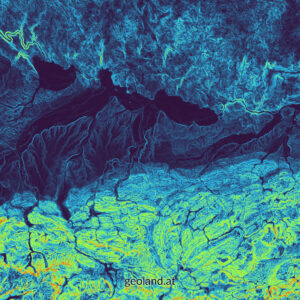
The result of a drone flight can be seen on the left. An orthomosaic with a resolution of 2 cm was created from true-color images, while the NDVI (Normalized Difference Vegetation Index) was derived from the multispectral images. You can switch between the two results using the slider in the middle.
Applications of drone data
3D models
3D models are used to visualize results in an appealing and easy-to-understand way.
Terrain models
Digital terrain models (DTM) and digital surface models (DOM) can be derived from drone images.
Vegetation indicators
A wide variety of indicator values can be derived from multispectral orthophotos, which allow deductions to be drawn about plant health and soil moisture, for example.
Classification of habitats
By analyzing multispectral orthophotos and various derived indicators (e.g. NDVI), habitats can be automatically identified across large areas. To achieve this, Machine Learning algorithms and AI are utilized.
Aerial photographs
Simple aerial photographs or oblique aerial photographs are ideal for obtaining a clear overview and documenting facts.
Orthophotos
Orthophotos are rectified images that show reality from directly above and at the correct geographical location. Drone images allow orthophotos to be created with centimeter-accurate resolution.
Vegetation checks (Precision Farming)
In agriculture, the condition of arable land can be precisely recorded using multispectral drone images. Conclusions can be drawn about: soil properties, soil cover, nutrient deficiencies, damage from feeding, erosion damage, drainage, diseases, biomass, fertilizer distribution, moisture, drought stress, edge zone effects, weeds, contaminated sites, game damage and stand density.
Forest monitoring
In forestry, drones can be used for forest inventory, to determine the condition of vegetation, to detect damage and to survey wildlife populations.
Photo and video production
Of course, my drones also allow the recording of attractive photos and videos. Simple photo and video editing is also part of my range of services.
Satellite images
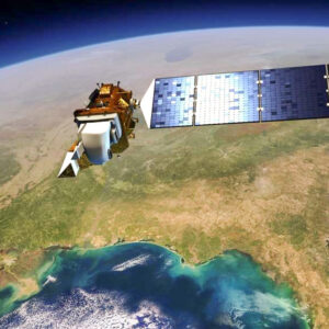
Satellites have been recording images of the entire earth’s surface for several decades. Some of this imagery is available free of charge and has a rough spatial resolution. However, there are also satellite images available, which have a very good resolution, but these have to be paid for. I have the most experience with the freely available Sentinel-2 images with 10m resolution. However, if the job requires it, I can also procure high-resolution satellite images.
Applications of satellite data
Historical picture series
Some satellite missions have been recording images since the 1970s, allowing long-term comparisons and developments to be analysed.
Vegetation indicators
A variety of indicator values can also be derived from satellite images, which allow conclusions to be drawn about plant health and soil moisture, for example.
Classification of habitats
By analyzing multispectral satellite images and various derived indicators (e.g. NDVI), habitats can be automatically identified across very large areas.
Field surveys
The classic collection of information on the ground in the field is also part of my range of services.
Mapping of habitats

I also offer surveying, demarcation and classification of biotope types and habitats in the field, although my service here is limited to practical implementation. I do not provide any nature conservation planning.
GNSS surveying

In modern field work, spatial information is no longer recorded by hand on printed plans. Instead, cell phones or tablets are used to record the information directly. The spatial information is immediately linked to the recorded data using GPS, GLONASS or GALILEO. The data is later manually organized or synchronised directly via the internet. I myself collect data in this way and am happy to help other companies introduce these methods.
Data management

GIS is a comprehensive software package that processes complex and diverse data. Geodata and GIS projects are not as easy to handle as Microsoft Office files, for example. For this reason, proper data management is particularly important here and is part of my range of services.
Daten acquisition
There is already a lot of geodata that is available free of charge under certain conditions. This ranges from satellite images and orthophotos, to property cadasters and street layouts, to the location of drinking fountains in Vienna. Thanks to many years of experience, I have good knowledge of the data available and am happy to share this knowledge with my customers.
Daten preparation
Geodata can usually not be used without a certain amount of preparatory work. Many users find it particularly difficult to work with coordinate reference systems (CRS). I offer to do this work in a targeted and project-oriented manner.
Georeferencing
Sometimes it is necessary to correctly locate images (maps, orthophotos, terrain sketches, etc.) in a GIS. This process is called georeferencing and is part of my range of services.
Tree register
For tree care and inspection, the locations of the trees are recorded as GIS data. This geodata contains additional information, such as a unique identification number, tending strategies and inspection intervals. The GIS data can be brought in the field on a mobile phone or tablet to easily and quickly locate the trees again. My service is the setup and management of such a tree register.
Pipe or wiring register
In a pipe or wiring register, information about pipes or cables is managed and provided with information about their type and condition. This is a planning basis for the management of water, district heating, electricity and internet lines, for example.
Hunting cadastre
Austria is divided into hunting areas, which in turn can be divided into different hunting grounds. Each hunting area has a person who is responsible – the hunter – and may contain other information. All of this can be recorded and managed using GIS.
Data analysis
The possibilities of spatial analyses in GIS are almost unlimited due to the large number of tools and their possible combinations. My services include all common standard GIS analyses and the development of special solutions, which are worked out together with the customer. I particularly enjoy solving new problems and developing new methodological approaches!
- Distance analysis
- Recreation planning
- Area statistics
- Habitat change
- River modelling
- Terrain analyses
- Visibility analyses
- Location analyses
- Classification of habitats
- Digitization
- AI-supported analysis
Visualisation

Regardless of whether it is the technical representation of cadasters or plans, or the presentation of complicated analysis results – a well-designed map can convey a lot of information quickly and easily. The creation of such maps, for the screen or for printing, is also part of my range of services.
Cartography
- Orthophotos
- Thematic maps
- Topographic maps
Training

Another of my services is GIS training. The include anything from basic courses for beginners to in-depth courses that deal with specific methods. The scope of the courses is adapted to the customer’s wishes and needs.
Training topics
- General introduction to GIS
- OpenSource and QGIS
- Open Government Data (OGD)
- Cartography
- Digitisation
- Spatial analysis
- Network analysis
- Geostatistics
- QField
- Workshops
Support

I am also available to my customers for any technical queries and general questions about GIS.
OpenSource
An essential part of my company philosophy is the use of open source software. Proprietary software can be very expensive, which is a challenge especially for small companies. However, there is excellent open source GIS software that is freely available (free of charge) and can easily compete with proprietary products. My methods and training are therefore largely carried out using open source software, which means that I and my customers can save money in the long term.